What Happened to Reynisfjara Black Sand Beach in 2026?
The short version, and the honest one, on the erosion that changed the beach and what you will actually see now.
 Written with Björn Einarsson, Iceland South Coast tour guide and local specialist
The short answer
In early February 2026 a large section of the slope beneath Reynisfjall collapsed onto the beach, and a run of powerful winter storms stripped much of the famously fine black sand, leaving more rock and pebble in places. The beach was never destroyed and did not disappear. The black coastline remains, but beach access is subject to warnings and closures, with the basalt columns and the Reynisdrangar sea stacks unchanged. It simply looks coarser than the postcard right now, and the sand is slowly returning.
The 10-hour Reykjavík minibus route makes Reynisfjara one stop in a varied day; access and the final itinerary remain subject to conditions. Check your South Coast date
Access update, September 25, 2026: SafeTravel reports viewpoint-only access during current stormy weather and high waves. Follow current warnings and closures; a tour booking does not grant access to restricted beach areas.
Search "Reynisfjara" today and half the results are before-and-after photos with captions like "the beach is gone". They are misleading. Something real did happen in early 2026, but the beach is very much still there. Here is what changed, without the drama.
To see the coastline as part of a wider day out, explore the minibus route that includes Reynisfjara, waterfalls and a glacier viewpoint. Explore the South Coast minibus route
What actually happened in February 2026
Two things hit at once. First, a large section of the loose slope beneath Reynisfjall, the mountain at the back of the beach, gave way and slid down onto the sand. Second, a series of unusually severe winter storms drove the Atlantic hard against the shore for days. Together they stripped away a lot of the fine, powder-black sand that made Reynisfjara so photogenic, and left coarser rock and pebble across parts of the beach.
Geologists were quick to point out that this is not a freak, one-off disaster so much as the coast doing what this coast does. Reynisfjara is a young, active volcanic shoreline. Sand arrives, storms take it away, and it rebuilds. The February event was simply a big, fast version of a normal cycle, caught on camera by a lot of visitors.
Is the beach gone or closed?
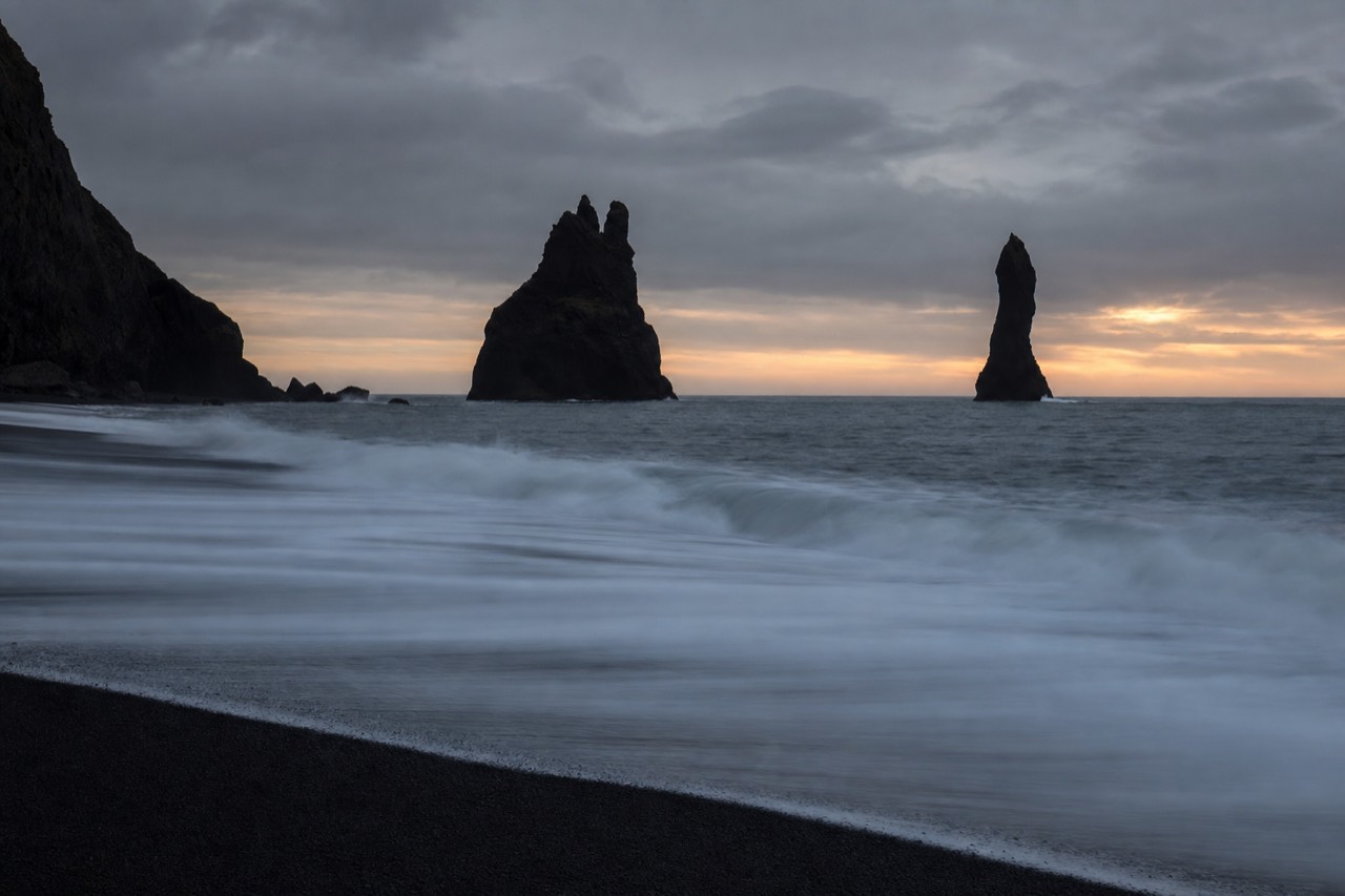
The coastline has not disappeared, but access can be restricted. On September 25, 2026, SafeTravel reported viewpoint-only access because of stormy weather and high waves, even without a red wave alert. The basalt columns, the sea cave and the Reynisdrangar sea stacks offshore are geology, not sand, so the storms did not touch them. What changed is the texture and the amount of fine sand underfoot, which varies now from one visit to the next as the shore rebuilds.
If you have Reynisfjara on your 2026 itinerary, the practical move is to see it on a guided day trip where someone checks the current conditions before you set off. Check the cancellation deadline before booking; weather can change after that deadline.
What you will see now vs the classic postcard
Here is the honest comparison, so you arrive with the right expectations.
| Feature | The classic postcard | Reynisfjara now (2026) |
|---|---|---|
| The fine black sand | Deep, powdery, jet-black | Patchier; more rock and pebble in places, sand slowly returning |
| Basalt columns (Gardar) | Sharp hexagonal "steps" | Unchanged |
| Reynisdrangar sea stacks | Tall pointed stacks offshore | Unchanged |
| Halsanefshellir sea cave | Columned cave in the cliff | Still there; check access on the day |
| The waves and danger | Deadly sneaker waves | Unchanged, still deadly, still the main safety issue |
| Overall drama | Otherworldly | Still otherworldly, just coarser underfoot |
Is it still worth visiting?
Yes, and this is not a close call. The features that make Reynisfjara one of the most striking beaches on Earth, the columns, the stacks, the black shore against a violent ocean, are all still here. A slightly rockier beach does not undo that. Visitors through spring and summer 2026 have kept describing it as unmissable, just different from the photos they had seen. If your only reference is a five-year-old drone shot of perfect powder sand, adjust the picture in your head and you will not be disappointed.
The one thing that has not changed, and never will, is the danger. Whatever the sand is doing, the sneaker waves at Reynisfjara are lethal and the reasons you cannot swim here still apply in full.
Is this kind of coastal change normal in Iceland?
Yes. Iceland's South Coast sits on some of the youngest, most volcanically active ground in the North Atlantic, and a beach gaining sand in one stretch and losing it in the next is how a coastline like this behaves, not a sign that something has gone uniquely wrong at Reynisfjara. Most of the region's black sand starts as basalt, worn down by surf and glacial meltwater and redeposited by current and wind. That is a two-way process. The same forces that build a beach up over years can strip a layer back off it in a single hard storm season, and then start rebuilding it again once the weather calms.
Older, more geologically settled coastlines change over centuries. This one can visibly shift texture within a season, which is jarring if your only reference is a photo from a few years back. What made the February 2026 event feel so dramatic was the combination and the speed: a slope collapse and a run of severe winter storms landing close together, not that erosion itself was new to this beach. Reading it as "the beach is destroyed" mistakes a fast, visible version of a normal cycle for a one-off catastrophe, the kind of framing that travels well on social media but does not hold up once you are standing there.
It is worth separating what actually moves from what does not. The columns, the sea cave and the Reynisdrangar stacks sit on solid rock and were never part of the sand cycle to begin with. Only the loose material on top of the beach comes and goes, and it has been coming and going for as long as this coastline has existed. Dyrholaey's arch nearby is the same story: carved from lava rock, weathering on a geological timescale that has nothing to do with a single storm season. What visitors are watching at Reynisfjara now is simply a more visible chapter of that same, ordinary story.
None of this means the beach looks identical to how it did a year ago, and it would be dishonest to pretend otherwise. It means the change fits a pattern this coastline has always followed, rather than being a warning sign that something is permanently wrong. Sand has returned to Icelandic beaches after past storm seasons before, and there is no reason specific to Reynisfjara to expect this time to be different, only a timeline that nobody can promise in advance.
It also helps to place the February event on the right timescale, since "coastal change" covers a few very different processes that move at very different speeds.
| Process | Typical timescale | What it changes |
|---|---|---|
| Storm-driven sand loss and rebuild | Weeks to a few seasons | Surface texture: how much fine sand sits on top of the rock |
| A slope or cliff-face collapse | A single event, sudden | Adds loose rock and debris to one area, as in February 2026 |
| The rock itself: columns, cave, sea stacks | Effectively unchanged on a human timescale | Nothing visitors will notice trip to trip |
Reading the event through that lens makes the "beach is gone" framing easier to see through. What visitors photographed in February was the fast, top layer of change, the kind that has already started reversing. The slow layer underneath, the layer that actually defines Reynisfjara, was never part of the story.
What does the beach actually look like underfoot right now?
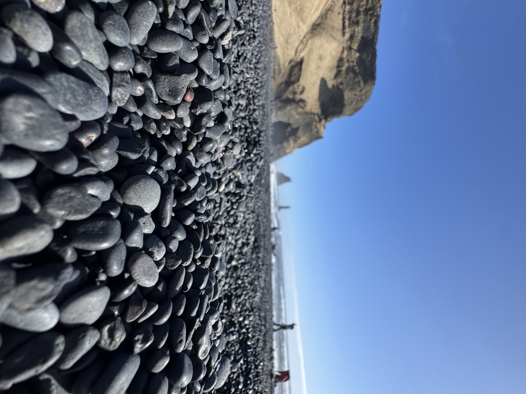
The texture is not uniform, so think in zones rather than one consistent surface: ground near the cliff and columns tends to be coarser rock and debris, the mid-beach is the most mixed pebble-and-sand stretch, and the strip nearest the water, which you should never approach, still tends to hold the finest, darkest sand. This is general, planning-level guidance rather than a fixed reading, since conditions shift with the tide and the weather from one visit to the next.
| Zone | What to expect underfoot | Best for |
|---|---|---|
| Near the cliff and basalt columns | Coarser rock and gravel, some loose debris from the slope | Viewing from permitted areas only; heed falling-rock warnings |
| Mid-beach | Mixed pebble and sand, texture varies visit to visit | Only where current access instructions permit |
| Near the waterline (stay back) | Finer, darker sand, still shifting with the surf | Distant photos only, never approach on foot |
There is a simple reason the zones differ. Ground closer to the cliff sits in the shadow of the slope that came down, so it caught more of the coarser debris. The open mid-beach took the fuller brunt of the winter storm surf, which is exactly the kind of energy that strips fine sand away first. Pockets closer to the water, where the sea is constantly reworking the material, can still show patches of the deep black powder people remember from photos, though that is exactly the zone you should never approach for a closer look.
For photography, this actually works in your favour if you plan for it. Wide shots that put the columns or the stacks in frame will read as dramatic regardless of the sand underfoot, since the eye goes to the scale of the rock, not the grain size. Close-up, sand-only shots are the ones most likely to look different from the older postcard images, so if that is the photo you specifically want, expect the texture to differ, and do not leave permitted areas to seek a photograph. Treat this table as a rough map for setting expectations, not a promise of exactly what you will find on a given day. A guide who was there recently, or a tour that checks conditions the morning of, will always know more than any table can.
This is also where the difference between a guided visit and a self-drive stop shows up most. The selected day-trip listing plans around 30 minutes at Reynisfjara. Whether guided or self-driving, visitors must follow current closures; a tour does not grant access to restricted sand, columns or cave areas.
Does the 2026 change affect which experience you should book?
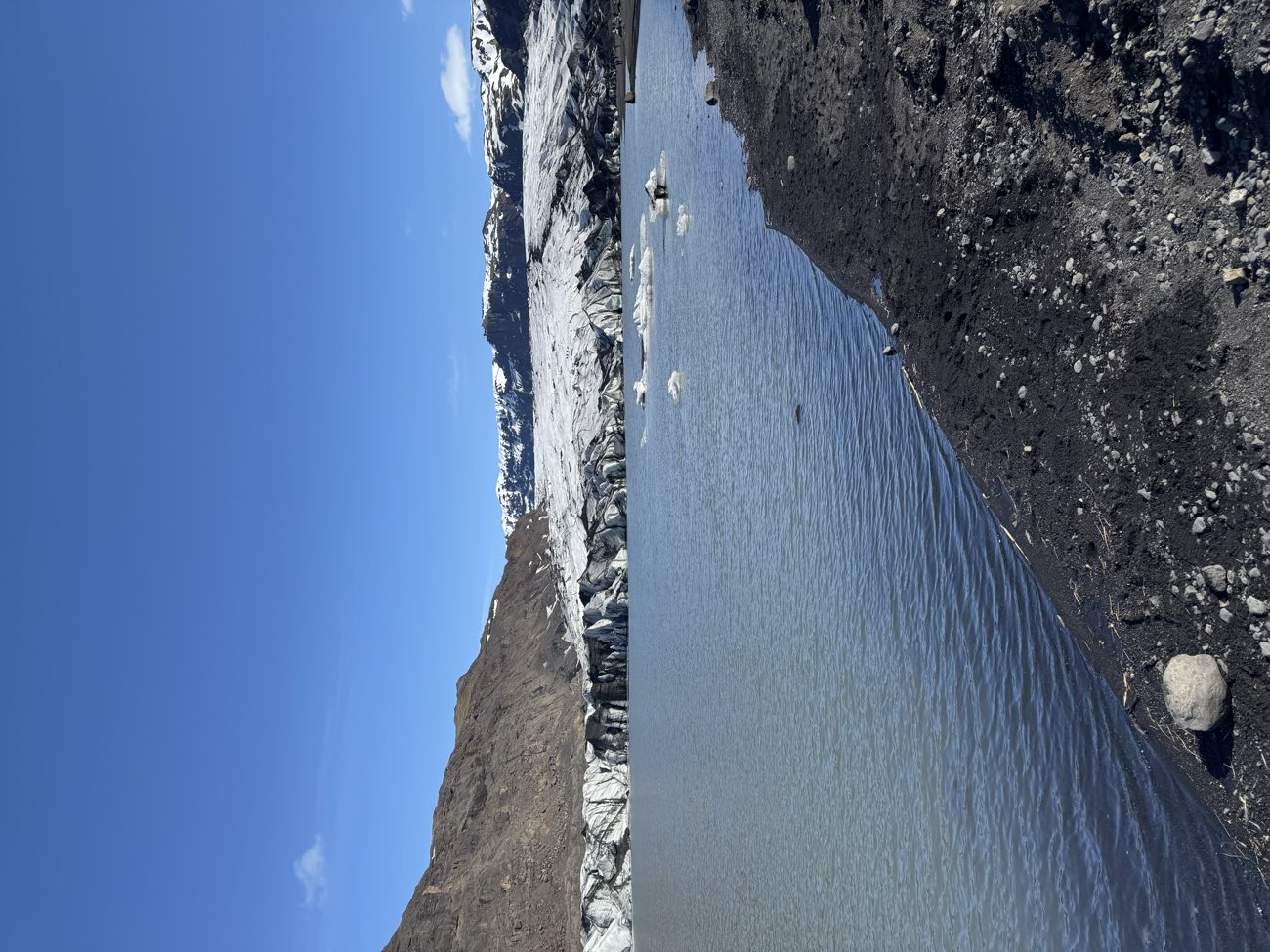
For most travelers, not much. If you came for the columns, the stacks and the sea cave rather than a specific sand texture, a planned Reynisfjara stop can still offer coastal views, subject to access restrictions, while you should confirm the current itinerary and cancellation terms before booking. The [South Coast day tour](https://www.getyourguide.com/reykjavik-l30/southern-iceland-tour-t67018/?partner_id=MME1WGW&utm_medium=online_publisher) still routes through Reynisfjara for its usual stop, alongside Skogafoss, the Solheimajokull glacier viewpoint and Seljalandsfoss on the same loop, none of which were touched by the February event at all. Skogafoss still drops its full curtain of spray, Seljalandsfoss still lets you walk behind the falling water, and the glacier viewpoint still looks out over Solheimajokull exactly as it did before.
If the sand specifically was the draw and a coarser beach would genuinely disappoint you, the same route offers two experiences that are not affected by any of this at all. The Solheimajokull glacier viewpoint stop shows a different kind of black-and-white volcanic drama, ice over ancient ash, and travelers who want to get closer can add the guided glacier walk as a separate booking: check availability here. That walk puts you on the ice itself with a certified guide and crampons, a texture and scale that has nothing to do with what is happening on a beach further down the coast. The separate Katla outing starts in Vík and visits a natural ice cave by Super Jeep; its own route and conditions still need checking.
Neither replaces Reynisfjara, and neither is being suggested here as a substitute for it. They are honest options if the sand disappointment matters more to you than the geology does, or if you simply want to add a second guided volcanic-landscape experience to the same South Coast trip. Most visitors, in practice, still find the 30 minutes at Reynisfjara worth the stop on its own merits.
Framed as a quick decision rather than a paragraph to reread, it comes down to what you actually came for.
| If you mainly came for | Then the 2026 change means |
|---|---|
| The columns, the cave and the sea stacks | Confirm current access and the planned itinerary before booking |
| A specific memory of powder-fine sand everywhere | Temper that one expectation, everything else still delivers |
| A separate guided ice or volcanic-landscape experience | Add the glacier walk or the Katla ice cave alongside the day trip |
| An efficient stop on a tight South Coast day | Check the planned stop duration and any current itinerary changes |
None of these rows require a different booking than the one most visitors already make. They are here to help you decide whether to add something extra, not to talk you out of the day trip itself.
Judge the tour against its current itinerary and access conditions. The selected minibus itinerary lists a 30-minute Reynisfjara stop alongside the waterfalls and glacier viewpoint; check the current route and cancellation terms for your date. If the beach itself were the only reason to book that route, the calculus above would matter a lot more. Since it is one striking stop among several, a coarser patch of sand at one of them barely moves the overall value of the day.
What Bjorn tells visitors before they go now
Bjorn's advice has not changed in substance, only in emphasis: check conditions the morning of, dress and shoe for a rockier walk than the old photos suggest, and remember that the things people actually come for, the columns, the cave and the stacks, have not moved an inch. Guiding the South Coast since 2022, he checks the current state of the beach against safetravel.is, road.is and the operator's own listing before each departure, the same verification routine he used before February 2026, just with one more variable to factor in.
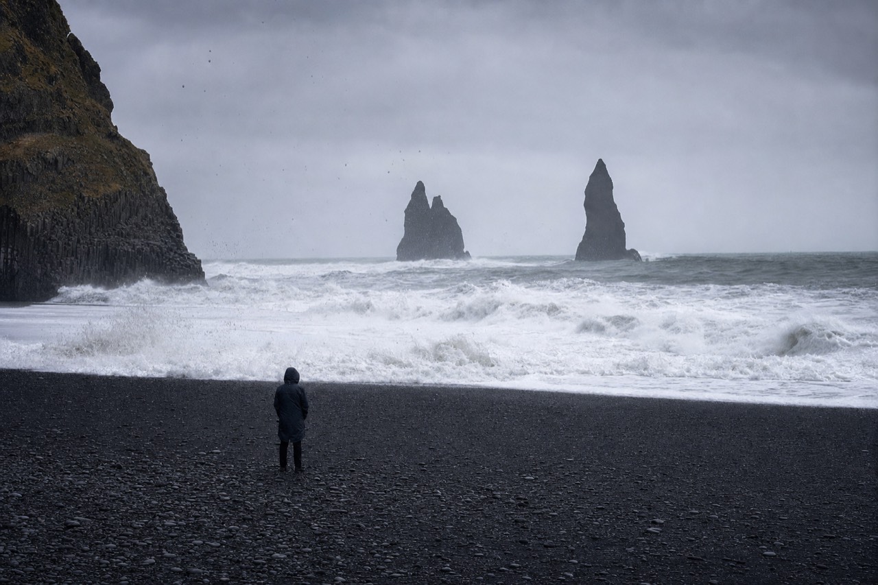
His practical line to first-timers is to lower the sand expectations and leave the rest alone. Wear shoes that handle loose rock and pebble, not sandals meant for soft sand, since footing near the cliff base is less even than it used to be. Expect a slightly slower walk in places where debris has settled, and allow time to read current warnings; do not go beyond the viewing area when restrictions apply. He also tells visitors not to over-plan around the sand at all: come for the scale of the columns and the stacks against the ocean, treat whatever the sand looks like that day as a bonus detail, and the visit tends to land well regardless.
And the one rule that has never moved with the sand: stay well back from the waterline regardless of what the beach looks like that day. The waves do not care whether the sand is fine or coarse, and a rockier beach does not make the water any less dangerous. If anything, uneven footing makes it more important to keep your distance rather than less.
The other thing he tells returning visitors, people who saw Reynisfjara before 2026 and are wondering whether to go back, is not to let a single set of before-and-after photos make the decision for them. He has kept bringing groups there through the changes because the reaction on the ground has stayed the same: people are still stopped in their tracks by the scale of the columns and the stacks against the ocean, coarser sand or not. His honest read, from someone who is on this stretch of coast most weeks, is that the disappointment people worry about ahead of time rarely matches what they actually feel once they are standing there.
How has the beach responded since February?
The recovery is gradual and ongoing rather than a single before-and-after moment: sand has been slowly returning to parts of the beach in the months since, following the same rebuild pattern this coast has always followed after a hard storm season, though the pace varies with the weather and nobody can promise an exact timeline. Guides who cover this stretch of coast week to week describe the change less as a fixed state and more as something that shifts a little with each visit, a patch of finer sand reappearing here, a stretch of coarser pebble persisting there.
That variability is honestly the most useful thing to know before you go. There is no single "current state" of Reynisfjara that a guidebook or an old blog post can capture and have it stay accurate months later. What is accurate is the pattern: storms strip sand, calmer stretches let it rebuild, and the beach has been doing some of that rebuilding since February rather than sitting frozen at its worst point. Whether a given week leans more toward the coarser end or the finer end depends on the weather that came before it, which is exactly why checking recent conditions matters more here than at most other stops on the South Coast route.
None of this changes the geology that actually defines the place. The columns, the cave and the sea stacks were never part of the sand story, and they are not part of the recovery story either, since they were never the thing that changed.
| Still the same as before February | Still gradually changing |
|---|---|
| The basalt columns and the sea cave | How much fine sand covers a given stretch |
| The Reynisdrangar sea stacks offshore | The texture underfoot from one visit to the next |
| The danger of the water, unchanged | Close-up sand photography, more variable than before |
| The tour's published route | Actual stops and access can change with conditions |
If you would rather check the current state for yourself instead of relying on general reassurance, there are a few simple ways to do it before you set off.
| Where to check | What it tells you |
|---|---|
| safetravel.is | General South Coast weather and road advisories |
| road.is | Route 1 driving conditions between Reykjavik and Vik |
| Your guide, on the morning of the tour | The most current, first-hand read on how the beach looks that day |
| The tour operator's own listing | Any posted notices about access changes at the stop |
None of these guarantee a specific sand texture on the day, since the beach keeps changing gradually rather than settling into one fixed look. What they do is put you in the same position as anyone checking honestly: informed about the general trend, not promised an exact outcome.
Common questions
Did Reynisfjara beach disappear?
No. Storms and a slope collapse in February 2026 stripped much of the fine black sand and left more rock in places, but the coastline remains; current warnings and closures determine which areas visitors may access. The sand is gradually rebuilding.
Is Reynisfjara closed to visitors in 2026?
Access can be restricted. SafeTravel reported viewpoint-only access on September 25, 2026 because of stormy weather and high waves. Follow the current instructions and closures on arrival.
Will the black sand come back?
Most likely, yes. Reynisfjara is an active volcanic shoreline where storms remove sand and the coast rebuilds it over time. Recovery is already underway, though the pace depends on the weather.
Should I still visit Reynisfjara after the erosion?
Yes. The features that make it famous are intact and visitors continue to rate it as a highlight of the South Coast. Just arrive expecting a coarser beach than older photos show. A guided day trip provides transport and a planned beach stop; follow current warnings and closures on arrival.
Choose Your Visit
Initial editorial recommendation. Check pickup and all operator requirements before booking.
Compare Options And Adjust Your Plan
- Iceland's South Coast Full Day Small-Group Tour from Reykjavik: Visit the South Coast waterfalls and the Reynisfjara area in a group of up to 18. 10 hours. Departs from and returns to Reykjavík. Follow current closures: sand, columns and cave access are not guaranteed. Confirm your pickup point.
- South Coast Day Tour Black Sand Beach & Waterfalls from Reykjavik: Combine the South Coast waterfalls and the Reynisfjara area on a shared coach itinerary. 10 hours. Departs from and returns to Reykjavík. Follow current closures: sand, columns and cave access are not guaranteed. Confirm your pickup point.
Iceland's South Coast Full Day Small-Group Tour from Reykjavik
Ready to include Reynisfjara in your trip? Check a South Coast departure for your date before organizing the rest of your itinerary.
10 hours. Departs from and returns to Reykjavík. Guide; Minibus transport; Reykjavík pickup. Meals and drinks cost extra.
Follow current closures: sand, columns and cave access are not guaranteed. Confirm your pickup point.
Choose your date on Viator while the schedule loads.
Scheduled departures only. Availability and final price are confirmed on Viator.